

If I were planning a weekend adventure ride in New Zealand, I’d split the options into two groups straight away: easy gravel distance and rough remote tracks. That’s the main call here.
In this guide, I’d be looking at North Island and South Island routes, then checking surface, distance, access, fuel gaps, weather risk, and bike fit before choosing one. Some rides are better on a big ADV bike, while others are far better on a lighter dual-sport equipped with the right adventure gear. A few key facts stand out fast: Rainbow Road is 112 km with a $60 toll, Nevis Road has 25+ river crossings, and Motu Road includes about 48 km of gravel over 67 km.
If you want the short version, here it is:
- Best for big bikes: Molesworth Road, parts of the Central Plateau, Coromandel loop
- Best for rougher riding: Nevis Road, Skippers Canyon, Motu Road
- Best for newer gravel riders: Mackenzie Pass, Hakataramea Valley Road
- Most remote picks: Rainbow Road, Molesworth Road, East Cape/Motu
- Main trip checks: access forms, seasonal closures, fuel range, offline maps, river levels, and weather
I’d also keep these route-by-route points in mind:
- Coromandel loop: around 300–450 km, mixed surface, good for a two-day ride from Auckland
- Raglan–Kāwhia–Marokopa loop: around 250–350 km, sparse fuel and few places to stay
- East Cape loop with Motu Road: around 400–600 km, remote, logging trucks, patchy to no signal
- Central Plateau: around 500–700 km, mixed seal and forestry gravel
- Rainbow + Molesworth: a classic South Island two-day pairing, but both are remote and weather-dependent
- Hakataramea/Mackenzie area: easier gravel, less pressure, better for building confidence
The main takeaway: I wouldn’t pick these rides by distance alone. I’d match the route to the bike, rider skill, season, adventure jackets for the conditions, and fuel range, then leave buffer time for fords, slips, dust, stock, and fast-changing high-country weather.
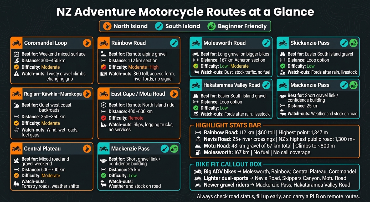
NZ Adventure Motorcycle Routes: Quick Comparison Guide
NZ Motorcycle Tour: Mud, River Crossings on the Rainbow Road!
sbb-itb-bfda696
Quick comparison
| Route | Best fit | Approx. distance | Main watch-outs |
|---|---|---|---|
| Coromandel loop | Weekend mixed-surface ride | 300–450 km | Twisty gravel climbs, changing grip |
| Raglan–Kāwhia–Marokopa | Quiet west coast backroads | 250–350 km | Wind, wet roads, fuel gaps |
| East Cape / Motu Road | Remote North Island ride | 400–600 km | Slips, trucks, no services |
| Central Plateau | Mixed road and gravel weekend | 500–700 km | Forestry roads, weather shifts |
| Rainbow Road | Remote alpine gravel | 112 km route section | Toll, access form, fords, no signal |
| Molesworth Road | Long gravel on bigger bikes | 167 km Acheron section | Dust, stock traffic, no fuel |
| Hakataramea Valley Road | Easier South Island gravel | loop option | Fords after rain, livestock |
| Mackenzie Pass | Short gravel link | 25 km | Weather and stock on road |
If I wanted one simple rule before setting off, it’d be this: check the road status on the day, fill up early, and assume you’ll be on your own for long stretches.
Before you go: Bike, access and weather checks
Before you head out, make sure the route fits your bike, the access rules and the weather window. That simple check can save you from turning up to a track that's too rough, too remote, or shut for the season.
Big-bike-friendly gravel versus technical four-wheel-drive tracks
Big adventure bikes work well on long gravel roads like Molesworth Road and Rainbow Road. Lighter dual-sports are a better fit for tighter, rougher tracks like the Nevis Road and Skippers Canyon.
That difference matters more than people think. The Nevis Road - New Zealand's highest public road at over 1,300 metres - has more than 25 river crossings. Skippers Canyon, first hand-carved by gold miners in the 1860s, means narrow cliffside riding with almost no room for mistakes. On tracks like these, a heavy loaded bike can go from helpful to hard work in no time.
Seasonal closures, permits and public access
Even if your bike is right for the route, access can still stop the trip.
Rainbow Road needs a completed access form and a toll. Molesworth Road opens seasonally under DOC control, usually from December to April. Outside that period, snow and ice can make both roads impassable.
As the Department of Conservation puts it:
"Unseasonal snows, slips or elevated fire risk may close the road without notice."
Before leaving, check the Rainbow Station website, the DOC alerts page and the Marlborough District Council website for closures or storm damage. If your route includes river crossings, check the River Care Code too. Riding in riverbeds between August and December is discouraged to protect ground-nesting birds.
Use this table as a quick guide for season timing and access rules.
| Region | Typical Season | Fuel Gaps | Phone Coverage | Access Notes |
|---|---|---|---|---|
| Marlborough (Rainbow Road) | Dec – April | ~112 km | None | Toll road; access form required; private land |
| Marlborough (Molesworth) | Summer only | ~200 km | Very limited | Private station; check DOC for seasonal opening dates |
| Central Otago (Nevis) | Summer/Autumn | ~65 km | Very limited | Public road; 25+ river crossings; avoid early spring snowmelt |
| Queenstown (Skippers) | Year-round (weather permitting) | Short but remote | Patchy | Narrow cliffside; often excluded from rental insurance |
Gear to pack for a New Zealand weekend ride
Pack the basics: a tyre repair kit, tools, first aid, water and food for an overnight stop.
Waterproof gear is a must. High country weather can flip from warm and dry to cold and wet within an hour. A waterproof adventure jacket, adventure boots with ankle support, and gloves rated for cold and wet conditions make a big difference when that happens.
Tyres matter too. Dual-sport tyres suit mixed-surface routes far better than road-biased tyres, which can struggle on loose shingle and through river crossings. For navigation, download offline maps before you leave. On most of these routes, mobile coverage is patchy or missing altogether.
Best North Island adventure routes
If you want a solid weekend ride without heading south, these North Island routes give you a strong mix of gravel, distance, and that out-in-the-sticks feeling.
Coromandel Peninsula gravel loop
The Coromandel is one of the easiest adventure loops to reach from Auckland. It suits riders who are happy on mixed-surface roads and gravel side-tracks. A typical weekend loop comes in at around 300–450 km.
If you want more dirt, add the Tapu–Coroglen Road and the 309 Road. The difficulty is moderate. The climbs are tight and twisty, and the gravel asks you to stay switched on. Two days makes more sense if you want to include the extra gravel sections.
Raglan, Kāwhia and Marokopa backroad loop
This west coast loop feels quieter, rougher, and a bit more exposed. It links Raglan, Kāwhia, and Marokopa through limestone country on narrow backroads and gravel sections.
The main risks here are wind, wet roads, blind corners, and very few services once you're out there. The loop runs about 250–350 km on a mix of sealed and unsealed roads. Difficulty is moderate.
Fuel matters on this one. Fill up before leaving Raglan. There are no reliable fuel stops between Kāwhia and Marokopa. Overnight stays are also limited, with Raglan or Te Awamutu the main options at either end of the loop.
For riders who want more distance and more isolation, the East Cape and Central Plateau can stretch a weekend ride quite a bit further.
East Cape and Central Plateau options
Motu Road runs for 67 km, with about 48 km of gravel, and climbs to nearly 800 metres over two major hills. There are no shops or fuel between Ōpōtiki and Matawai, and mobile coverage is almost non-existent. Logging trucks use parts of the road, so always pull over and keep left on blind corners. A full East Cape loop from Ōpōtiki or Gisborne covers about 400–600 km over a weekend.
If you want something less remote but still mixed-surface, the Central Plateau is a good fit. It combines longer sealed stretches with forestry gravel. The route moves through volcanic country around Tongariro National Park and farmland backroads linking Taupō, Taumarunui, and National Park village. Expect a mix of seal and forestry gravel, with a 500–700 km weekend loop from Auckland or Hamilton.
| Route | Surface mix | Approx. weekend distance | Difficulty rating | Weather sensitivity |
|---|---|---|---|---|
| East Cape (Motu Road) | ~70% gravel on Motu section | 400–600 km | Remote | High - prone to slips and fords |
| Central Plateau | Mixed seal and forestry gravel | 500–700 km | Moderate | Moderate |
Best South Island adventure routes
South Island routes are longer, more remote, and more exposed to alpine weather. That means conditions can turn fast. The smart move is to plan on the safe side and leave yourself plenty of buffer.
Rainbow Road and Molesworth Road
A solid two-day ride is Rainbow Road on one day, then Molesworth Road on the next.
Rainbow Road runs for 112 km from Hanmer Springs to St Arnaud and climbs to 1,347 metres at Island Saddle, the highest watershed between the Wairau and Clarence Rivers. It’s a private toll road, with a $60 access fee per vehicle, and you need to fill out an access form before riding. Expect loose gravel, steep sections, and rough stream fords. This one suits riders who are comfortable with long, remote gravel days.
Molesworth Road is a bit easier, but it’s still remote country. The Acheron Road section covers about 167 km of mostly well-graded gravel through New Zealand’s largest high-country station. One thing to watch: cattle trucks can kick up a lot of dust and make visibility poor. Both roads are seasonal and usually open from Labour Weekend or late December through to Easter. Because Molesworth is a working farm, riders need to stay on the road, and off-season access can require DOC permits.
There are no fuel stops on either route, so fill up in Hanmer Springs, St Arnaud, or Blenheim/Seddon. Cell coverage is non-existent on both roads, so carry a PLB.
Hakataramea and Mackenzie Country
For a less demanding South Island weekend, the Mackenzie basin is a better bet. It gives you easier gravel and less exposure than the bigger alpine routes.
For a simpler option, Mackenzie Pass is a 25 km gravel link from Kurow into Hakataramea Valley Road and Haldon Road. These roads work well for riders building confidence on gravel, or for people on heavier bikes that don’t suit rougher terrain. They’re a good fit for bigger bikes and newer gravel riders. Keep an eye out for livestock on the road and fords that can rise fast after rain.
| Route | Technical difficulty | Route notes |
|---|---|---|
| Rainbow Road | Moderate–High | Loose gravel, river crossings, no cell service |
| Molesworth Road | Low–Moderate | Long, remote, dusty, no services |
| Hakataramea Valley Road | Low | Fords after rain, livestock on road |
| Mackenzie Pass | Low | 25 km gravel link; forms a loop from Kurow with Hakataramea Valley Road and Haldon Road |
Use the distance, surface, and difficulty as your guide when matching a route to your bike and the time you’ve got for the weekend.
Choosing the right route
Match route difficulty to your bike and experience
Use the route summaries above to line up the surface, remoteness, and access with your bike. The right route depends on both bike weight and rider skill.
Light and mid-weight adventure bikes tend to handle rougher tracks better. Heavier bikes are usually a better fit for long, well-graded gravel roads. If you're new to gravel riding, start with easier routes like Molesworth Road before stepping up to tougher terrain.
Build a realistic two-day itinerary
Aim for 250–350 km per day, with enough time for rough sections, photo stops, fuel breaks, and the odd delay. On New Zealand gravel, distance on the map doesn't tell the whole story. Pace, weather, and access windows matter just as much.
Remote gravel rides often take longer than they look, so it pays to keep the days shorter and leave some buffer time. Plan around fuel, access, and delays, not just kilometre totals.
Key takeaways
Check access, fuel range, and weather before you leave. Pack road and off-road rider gear, water, food, and warm layers so you can stay self-sufficient on remote routes.
FAQs
Which NZ route suits my bike best?
It depends on your bike and the kind of terrain you like riding. Tough off-road bikes usually make more sense for mountain trails and remote backcountry tracks. More flexible bikes, on the other hand, often suit scenic rides that mix gravel with sealed roads.
The main thing is to match your bike’s engine capacity, suspension, and tyres to the route difficulty and trail conditions outlined in the article.
How much fuel range do I need?
Plan for at least 200 km per tank. That gives you enough range to cover the kind of daily distances many riders do on adventure trips in NZ without feeling like you're constantly hunting for fuel.
It also lines up well with an average riding day of around 207 km, while leaving a bit of breathing room for fuel stops on remote routes.
When are these adventure routes open?
These adventure routes in New Zealand are usually open from 1 October until Easter Monday or the second Sunday in April, whichever comes first.
That said, seasonal conditions can still force closures. So before you lock in your trip, it pays to check access first.